Each of the Scottish Ten sites raised its own particular digital documentation challenges, and a wide range of technologies was used to accurately capture data.
Remaining at the cutting edge of developments ensures that we deliver the best quality spatial data for an ever-growing range of heritage applications.
Laser scanning was the main technique used in the Scottish Ten fieldwork, while most of the others below proved useful at some stage.
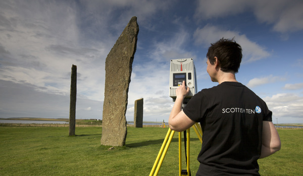
Close-range, terrestrial and aerial 3D laser scanning were used to digitally document the Scottish Ten sites.
Laser scanning allows the 3D surface geometry of objects to be recorded in a digital form. A large amount of 3D data can be collected in a short time frame. Scanning can be done from a static position on the ground or from aircraft –when it’s usually known as LiDAR (Light Detection And Ranging).
Accuracy and resolution depend on the laser scanning technology used, which in turn depends on the scale of the surface to be scanned. Small-scale objects (around 1m across) can be recorded with a very high degree of accuracy (to 10s of microns). Scans of building facades and such structures may have an accuracy of 4–6mm.
Laser scanning benefits include:
ability to create a 3D snapshot of the as-built environment
accuracy of range – terrestrial systems can be used to scan objects from 50cm to 300m away with an accuracy of up to 4mm
close-range systems can be used to scan with sub-millimetre accuracy
rapid data capture – 1 million points per second
option to use point clouds with other datasets – e.g. traditional survey, GPS, high-resolution photography, thermal imagery, moisture mapping
varied point cloud data uses – e.g. condition monitoring, building information models, virtual reality tours and immersive experiences
How it works
A laser beam scans the object’s surface up to 1 million times every second, and the reflected laser light is used to compute the distance to the surface. This results in up to 1 million spatially accurate coordinates (or points) being collected every second.
The data is used to produce a ‘point cloud’, which accurately defines the surface geometry of the object. This is very useful in itself, but it can also be further processed to produce 3D models and outputs in other forms.
Scans must be taken from several angles to obtain optimum point cloud data. Complex objects will need to be scanned from more viewpoints to avoid missing important details. Scans must also overlap to enable them to be joined together.
To record the geographical position of the object, the Global Positioning System or Global Navigation Satellite System can be used to survey points within the scan. It can then be positioned accurately within a known grid system.
Types of terrestrial scanner
Triangulation scanners – used at close range to capture details on carvings and other small objects up to a few metres across in size
Phase comparison scanners – fast with a medium range (around 70m), so can quickly cover interiors where many scans are required
Time-of-flight scanners – with ranges of up to or over 300m, these can scan architectural objects, engineering structures and landscapes
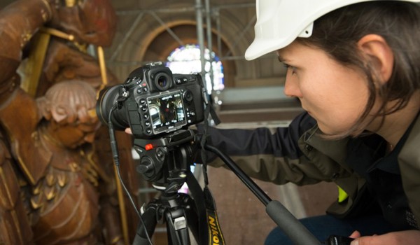
Digital documentation trainee Nicole Burton undertaking photogrammetry of the Chapel Royal altar cloth at Stirling Castle.
For over a century, people have used photogrammetry in cartography and aerial surveillance.
Today, we use it to produce 3D datasets of buildings, places, and objects in our historic environment, as part of the Rae Project.
History of photogrammetry
French Inventor Aimé Laussedat developed photogrammetry as a concept in 1851.
Early photogrammetry took advantage of advances in photography. Images could be taken from different angles and locations, and combined with angular and distance measurements to accurately place points in the landscape.
It began to be adopted more widely in the early twentieth century with the introduction of terrestrial photogrammetry, and First World War aerial photogrammetry.
Modern photogrammetry relies on similar principles but uses computer vision algorithms to align the digital photographs and create 3D data points from them. This is called ‘Structure from Motion’ (SfM) photogrammetry.
We use this in digital documentation to record historical subjects, from small artefacts, to buildings and landscapes.
Our semi-automated photogrammetry system for digitally documenting portable collections items. It is customised to efficiently capture objects of different sizes and materials.
How photogrammetry works
Digital photographs are put through different algorithms. These algorithms calculate the camera positions from the photographs and combine them into one 3D space. This process is called an alignment.
Once the photographs have been aligned, high resolution 3D data is generated and used to produce detailed 3D “surface geometry”. This is a digital representation of the features of the building or object photographed.
This data can be represented as a collection of high-resolution 3D coordinates (a “point cloud”), or connected 3D surfaces as a 3D model.
Sometimes we use drones as part of this process. They help us to access hard-to-reach areas of our sites and gain new perspectives of them.
We add laser scans, high resolution texture maps (complete with fine details, surface textures, and colours), and terrestrial and aerial data to build a more complete representation of the sites.
To use the 3D data for measurements, photogrammetry needs a scale. We have to input a known distance between two points to provide this scale reference.
From there, the software can calculate the rest and transform the 3D data to the correct scale. Most photogrammetry software packages include support to accurately scale the 3D data.
Unmanned Aerial Vehicle (UAV) recording high-level imagery of buildings at Fort George. Flying and aerial photography by Building Conservation Technologist & UAV Pilot Scott Hamilton.
Quality and processing
Missing or limited photography can impact the accuracy and quality of the data. This will result in “holes” and missing sections of data.
Other factors which might affect the quality of 3D data and how long it takes to process include:
complex subjects
materials including repeating patterns, smooth and featureless surfaces, and refractive and highly reflective materials like metals, glass, polished ceramics, minerals, and plastics
photography environment, i.e. lighting conditions and exposure
software operator knowledge and technique
photography knowledge and technique
camera systems, including sensor resolution and lens quality
available software
specifications of processing hardware
Consider these factors when planning any photogrammetry projects.
The benefits of photogrammetry
The benefits of completing photogrammetry to a high standard throughout the process are:
high accuracy, high resolution 3D data at different scales
high quality images to create texture maps
access to challenging areas during surveys, with mobile camera systems
The Digital Documentation and Innovation team documents our heritage in 3D with cutting-edge technologies. They use this data in new and innovative ways.